Posts

Featured Posts

Restoring Kasaana- Nabyewanga wetland ecosystem in Lwengo District

Image
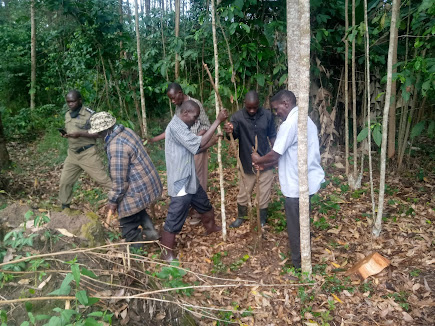
Kasaana- Nabyewanga wetland is located in Lwengo District, where the ACCP is having an active project aiming at conserving the Kiyanja-Kaku wetland. The wetland is approx. 65.2 acres within the Kiyanja-Kaku wetland catchment and is share by two villages of Kasaana and Nabyewanga, hence the name. A wetland buffer zone demarcation exercise was carried out with championship by the village wetland management committees that were set during the previous sensitization meetings, this committee was set up with gender and other marginalized groups focused on -A total of 6 individuals (2 females and 4 males) in Kasaana village and 5 individuals (2 females and 3 males) in Nabyewanga village were initiated as the committee where youths were also represented . This demarcation was also attended by the environment Police for Lwengo district, and the village local council leaders. During the exercise, Ficus natalensis tree species were used. 168 Poles were delivered on-site by the local members

Community sensitization meetings towards Restoration of Kasaana- Nabyewanga wetland ecosystem in Lwengo District

Kasaana- Nabyewanga wetland is in Lwengo District of South-Central Uganda. The wetland is share by two villages of Kasaana and Nabyewanga and hence the adopted name to the wetland. The re are ecosystem resources obtained from this wetland such as clean water, medicine, building materials, and others are therefore shared by both the two villages. The wetland is critically important as feeding and sometimes a breeding ground for the endangered Grey  Crowned  cranes , a bird listed endangered on the IUCN red list of species . Under the African Crane Conservation Program(ICF/EWT partnership projects), Our routine monitoring has revealed that several pairs exist and sometimes a flock of 6 and above cranes is found in this part of the wetland feeding on rice, insects, and others. However, this wetland is highly threatened by agriculture encroachment where rice growing, maize, and sugarcane growing are the major activities. This wetland is the only source of water for the Households here bu

MY WETLAND CONSERVATION ACTIONS IN UGANDA- MOTIVATION, CHALLENGES, AND HOPE!

Image
My name is Gilbert Tayebwa, a 30 years old climate and Wildlife conservation actor in Uganda, am also a Youth Global Landscape Forum(GLFx) Chapter Coordinator in Southcentral Uganda-Lwengo-Kyazanga Chapter. Currently am working for the International Crane Foundation(ICF) an International NGO that has been championing research and conservation of the Worlds crane species. In Uganda, Am  building a career in natural resources conservation with more focus on serving to contribute towards safeguarding the  endangered Grey   Crowned  Crane species.  My  background is in Environmental Conservation and Natural Resource Management from Makerere University, Uganda I have experience in community organization sensitization & engagements, environmental education, GIS & Remote sensing skills, ecosystem-based research. As a wildlife biologist, am also passionate about community conservation, technology, and innovation in wildlife conservation and management. My key focus for Uganda is on ec

Piloting a restoration project in Rushebeya wetland to save the Endagered Grey Crowned Crane in Rukiga landscape , south western Uganda

Image
  For Ecological Restoration to be successful, drivers of disturbance which include livestock restrictions, and eradicating invasive exotic species from the restored young area need to be removed to enable the young vegetation to grow uninterrupted.  This has been noticed in Gilbe rt Tayebwa's piloted restoration activity in Rushebeya wetland of Rukiga District where, Gilbert managed to task group leaders to sensitize people especially wetland adjacent communities and those using the wetland for agricultural purposes to restore buffer zones of at least 50meters from the river bank into the agricultural area for safer breeding and feeding of Grey Crowned Cranes, and endangered species according to the IUCN Redlist and a national bird for Uganda .Communities here were told t o also monitor the restored areas periodically   However, for Restoration to be effective, there is need to offer incentives such as Conservation agreements or revolving loans or else alternative liveli

Uganda's Geospatial transformation

Focusing on technological developments, Uganda, in Particular, is adopting/increasing her potential to grow though use of geo-information technology to address climate change, biodiversity conservation, social and cultural( https://www.seed.manchester.ac.uk/about/stories/mapping-way-ugandas-mll-victims/ )developments including industrial developments. This has been realised by the diversity of geospatial data providers , national mapping and space agencies, policy makers and research institutes taking up this leading technlogy Increase use of this will enable adequate contribution to the country to contribute to achieving the(Vision 2040 ) thence focusing on the role and relevance of geospatial information in national development will support the country's growing economy and attracting the interest of governments and businesses from around the world.

Geography for Development and Biodiversity conservation(Sustainable approach)

Image
Despite the challenges caused by developeemt, there is still a strong link between biodiversity conservation and economic development anywhere in the world.  A major point in time is  the setup of an indutrial farm in an area not being  established in major buiodiversity zone  such as bird or other species migration corridor/routes. This will most likely have a low impact on the biodiversity while keeping the developemt serving its purpose thence generating capital for the state.  On the other hand,seting the same developemt in the entities aforementioned route will disrup movement or else kill species on the move including (Near threatened,vunerable species) thence resulting in economic losses due to the regular interruptions of the developement caused by the regular species-developemt collisions. This way, both the economy and environment are affected. There is therefore a very urgent need for scientists to form strong partnerships that allow for well-informed decisions

Importance of Open data

Image
Incorporating Geography as a useful tool for preparing the input of models and tool is critical. Moreover, a lot of data is available in this era of Open Data and It can be easily retrieved from the internet and integrated into open source GIS desktop software, such as QGIS , open layers used for web-mapping and data querying(review my github projects here . Often,some data is stored in files on harddisks,  or DVDs,making  it hard to be found including lack of metadata thence makes it hard to evaluate the quality of the data and to reuse the data  It should be noted that, data shared/visualized in maps leads to more insights and better policy making. Sharing data in the cloud lets data users spend more time on data analysis rather than data acquisition With this versatile open source program you can compile a map by organizing, combining and linking data. Analyze the data, add your own layout and prepare the map for publication